|
These guides form a grid based upon the location of the
observer, and the measurements of altitude and azimuth.
Altitude measures the angle of an object above or below the
horizon. (The local horizon is a base line of 0°,
counting up to the Zenith at 90° and down to the Nadir
of -90°.) Azimuth is based on the compass direction of
an object. This angle is measured from the north (0°),
through the east (90°), the south (180°), west
(270°), back to the north again at 360 or 0°.
- Note: Local Guides are based on
your local horizon, which appears slightly above the
actual horizon due to the refraction of light in the
atmosphere.
Options for the Local Guides
To turn on or off the various local guides (a reference
plane, the local meridian, the line that divides the sky
into east and west, the local horizon and zenith and nadir
points ) open the Options dialog by selecting "Options..."
from the Settings menu, then pick "Local Guides" from the
popup menu. Alternatively, click the options
button for Local Guides in the Display palette.
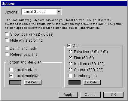
Show Local Guides: This checkbox performs a
similar function to the Guides/Local Guides menu command.
Check this box if you want Local Guides shown. Note: The
checkbox will be dimmed unless one of the Local Guides has
been selected.
Hide While Scrolling: To improve performance on
slower machines, you can check this box so that Local Guides
are turned off while scrolling.
Zenith and Nadir: When checked, displays Zenith
(the point directly above you) and Nadir (the point directly
below you).
Reference Plane: When checked, a local reference
plane is displayed, with the Sun at its center.
Horizon and Meridian
Local Horizon: When checked, displays
your local horizon. Note: your local horizon appears
slightly above the actual horizon due to the refraction
of light by the atmosphere.
Local Meridian: When checked, your local
meridian will be displayed.
Set Color: By clicking on this button, you can
select a new color for the equator and meridian
guides.
Grid: Checking this box turns an altaz grid on,
and allows you to adjust how the grid is displayed. Checking
the "Number Grids" checkbox will display the altitude and
azimuth number of each gridline.
Set Color: By clicking on this button, you can
select a new color for the Local Guides.
|